Exploration evidence boundary
Hyperspectral Mapping: How AI is Revolutionizing Low-Impact Quartz Extraction
A pale yellow quartz point on a seller’s table may come with a clean origin story. The mine behind it is a separate question.
In accurate geological language, AI Crystal Mining means using AI-assisted mineral mapping to read hyperspectral and geospatial data, then prioritize likely quartz-bearing targets or quartz veins before more ground is disturbed. It can support lower-disturbance exploration by narrowing where teams drill, trench, sample, or send crews first.
It does not prove finished crystals are present. It does not prove the quartz is gem-quality. And it does not make extraction low-impact by itself. That stronger claim needs field validation, permits, environmental controls, community safeguards, reclamation planning, and independent responsibility checks.
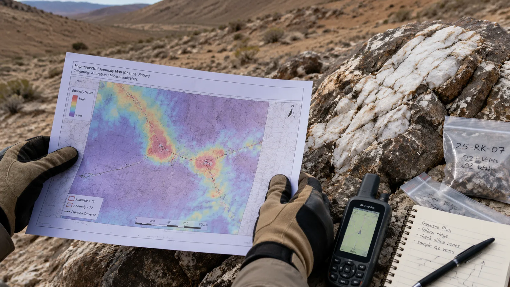
broader context
Citrine verification note
This narrower page works best after the broader citrine reference page.
What hyperspectral mapping can actually show
Hyperspectral mapping starts with a material fact: minerals interact with light in measurable ways. Public spectroscopy work, including USGS spectral-lab resources, supports the basic principle that mineral materials can be compared by spectral response when the data are collected and interpreted carefully. NASA’s AVIRIS program also shows that imaging spectroscopy is a real airborne remote-sensing discipline, not just mining sales language.
The overstatement to avoid
For quartz exploration, the useful point is not that a satellite “sees crystals underground.” That is the overstatement.
The cleaner version is this: hyperspectral sensors collect many narrow wavelength bands. Analysts compare those data with known mineral behavior, local geology, and visible surface conditions to map likely mineral signatures, alteration patterns, exposed veins, silica-rich zones, or associated rock units. AI and machine learning can help classify complex spectral data that would be slow to sort by hand.
That matters because quartz veins often sit within broader geological settings. A map may highlight exposed vein material, mineralized outcrops, alteration halos, or surface patterns that deserve field checking. It may also help separate one surface material from another across a large area.
But a mapped anomaly is still an exploration lead. It is not a gemological report, a mining permit, or an ethical-origin certificate.
For citrine buyers and quartz collectors, that distinction matters. A cleaner discovery process can be part of better sourcing language; it does not replace disclosure about whether the material is natural citrine, heated amethyst, smoky quartz, synthetic material, or commercial quartz sold with a polished story.
How AI-assisted mapping may reduce exploration disturbance
The strongest low-impact argument sits at the exploration stage. If satellite mapping, airborne imaging, outcrop scanning, or drill-core hyperspectral workflows help teams focus on a smaller set of plausible targets, then fewer speculative site visits, trenches, roads, or test areas may be needed.
That is the careful version of the “revolutionizing” claim.
A realistic workflow
1. Collect spectral and geospatial data.
This may include satellite mapping for quartz veins, airborne imaging spectroscopy, outcrop scans, or hyperspectral drill-core scans.
2. Compare mineral behavior against references.
Spectral libraries and geological context help analysts judge whether a signal resembles a mineral, alteration pattern, or surface material of interest.
3. Use AI to classify patterns.
Machine learning can help sort high-dimensional hyperspectral mineral signatures, especially where many narrow wavelength bands create large datasets.
4. Prioritize anomalies for field validation.
The map becomes a triage tool. It helps decide where geologists should look first, not what anyone should accept without checking.
5. Keep exploration success separate from extraction responsibility.
Even a confirmed quartz-bearing vein still needs environmental review, social safeguards, operational controls, and reclamation planning before anyone can call extraction low-impact.
Peer-reviewed hyperspectral mineral mapping work supports the broader idea that imaging spectroscopy can help map mineralized outcrops. Drill-core studies also support workflow concepts such as spectral unmixing, endmember extraction, mineral mapping, and vein detection from hyperspectral scans.
Those mechanisms are useful. They do not prove a universal quartz-mining result.
The practical benefit is better targeting. Better targeting may reduce blind exploration. The claim should stay there unless a specific project shows more.
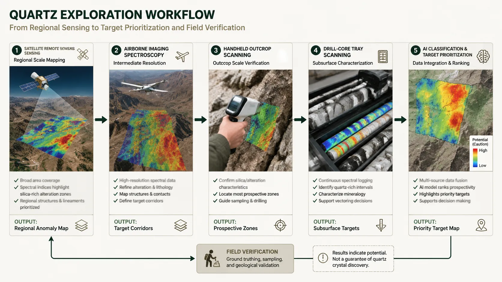
Satellite mapping, airborne imaging, and drill-core scanning are different stages
A lot of confusion comes from treating every remote-sensing tool as one process. They are related, but they answer different questions.
Method
What it can help with
Main limit
Satellite mapping
Broad screening over large or hard-to-access areas; surface patterns; regional anomalies
Resolution, vegetation, soil cover, weather, and mixed surface materials can limit interpretation
Airborne imaging spectroscopy
Higher-detail imaging spectroscopy over selected areas
Usually reads surface or near-surface signals, not finished crystals underground
Outcrop hyperspectral mapping
Detailed study of exposed rock and mineralized surfaces
Only works where useful material is visible or accessible
Drill-core hyperspectral scanning
Mineral mapping and vein detection inside recovered core
Requires drilling first; it is not a no-disturbance method
AI classification
Pattern recognition across complex spectral datasets
Depends on training data, ground truth, analyst skill, and geological context
This separation keeps “AI Crystal Mining” from becoming a fantasy phrase. AI can help interpret data from satellite mapping, airborne surveys, outcrop studies, or drill-core scans. It cannot collapse the whole chain from remote image to responsible quartz extraction.
There is also a quartz-specific caution. Quartz can be spectrally difficult depending on wavelength range, surface condition, grain size, mixture with other minerals, and whether the target is exposed. In many settings, mapping may rely on associated mineral signatures or geological context rather than a clean, isolated quartz-vein signal.
That does not make the method useless. It makes field validation essential.
Where low-carbon mining language can mislead
Low-carbon mining is a broader operational claim than low-disturbance exploration. Hyperspectral quartz mapping may reduce unnecessary exploration movement in some settings, but carbon impact depends on equipment, fuel, energy sources, transport, processing, waste handling, and site operations.
A sharper map does not automatically make a mine low-carbon.
Responsible quartz extraction has the same problem. It cannot be inferred from a beautiful anomaly map. Responsible-mining frameworks such as IRMA look at issues mapping technology alone cannot settle: environmental assessment, water management, waste handling, biodiversity, worker protections, community engagement, Indigenous rights, emergency planning, and reclamation.
Those questions live outside the spectral image.
This is where market language often gets ahead of the evidence. Phrases such as “de-risking,” “whole-area scanning,” “beyond the visible,” or “ESG-compliant supply chain” can sound reassuring. Some of that language describes real technology goals. It should not be read as proof that a specific quartz deposit was extracted with low disturbance, low carbon output, or strong community protections.
For a shopper, the cleaner question is not “Was AI used?” It is: What did AI help decide, and what separate evidence supports the extraction claim?
If the answer stops at a map, the sourcing story is incomplete.
What would make the claim stronger
A responsible claim about AI-assisted low-impact quartz extraction would need a chain of evidence.
The exploration part would need to show that hyperspectral or satellite mapping identified specific anomalies, that those anomalies were checked on the ground, and that the targeting meaningfully narrowed disturbance compared with a less focused campaign.
The extraction part would need separate documentation: permits, environmental assessment, water protections, waste and land-management plans, worker and community safeguards, and reclamation commitments.
For quartz sold into the crystal market, another layer still remains. Mapping a quartz vein does not identify a citrine specimen as natural, heated, synthetic, untreated, or gem-quality. Those questions belong to gemological verification and seller disclosure. A technology-forward origin story can be interesting; it should not crowd out treatment history, material identity, or transparent sourcing language.
The available evidence supports a cautious mechanism story:
- Minerals can have measurable spectral behavior.
- Hyperspectral sensors can collect many narrow bands of data.
- Imaging spectroscopy is used in mineral mapping.
- AI can help classify complex spectral patterns.
- Mapped anomalies can guide field validation.
- Better targeting may reduce some unnecessary exploration disturbance.
It does not support saying AI reliably finds all quartz veins from orbit, verifies finished crystal quality, replaces geologists, or proves low-impact extraction.
A useful way to read “AI Crystal Mining” claims
When a quartz or citrine seller, mining story, or technology article uses the phrase “AI Crystal Mining,” translate it into more precise questions:
- Was this satellite mapping, airborne imaging, outcrop scanning, or drill-core analysis?
- Did the system map exposed quartz, associated minerals, alteration patterns, or broader anomalies?
- Were mapped anomalies field-validated?
- Did the technology reduce exploration disturbance, or is that only implied?
- What separate evidence supports environmental safeguards, community process, and reclamation?
- Does the seller still disclose treatment, origin limits, and material identity clearly?
If those questions are answered plainly, AI-assisted hyperspectral mapping can be part of a better sourcing conversation. If they are not answered, the phrase is mostly futuristic packaging.
The useful conclusion is modest: AI can help make quartz exploration more targeted by interpreting hyperspectral and geospatial data, and that may support lower-disturbance exploration when paired with field checks. Verified low-impact extraction is a different claim. It needs proof beyond the map.